Published work:
[3] Li, L., DiBiase R. A., Del Vecchio J., et. al. (2018), Investigating the Effect of Lithology and Agriculture at the Susquehanna Shale Hills Critical Zone Observatory (SSHCZO): The Garner Run and Cole Farm Subcatchments. Vadose Zone Journal doi.org/10.2136/vzj2018.03.0063
[2] Del Vecchio, J. DiBiase, R. A., Denn, A. Bierman, P., Caffee, M.W., and Zimmerman, S. R. (2018), Record of coupled hillslope and channel response to Pleistocene erosion and deposition in a sandstone headwater valley, central Pennsylvania. Bulletin of the Geological Society of America doi.org/10.1130/B31912.1
[1] Del Vecchio, J., Lang, K. A., Robins, C. R., McGuire, C. and Rhodes, E. (2018), Storage and weathering of landslide debris in the eastern San Gabriel Mountains, California, USA: implications for mountain solute flux. Earth Surface Processes and Landforms doi.org/10.1002/esp.4427
Ongoing work:
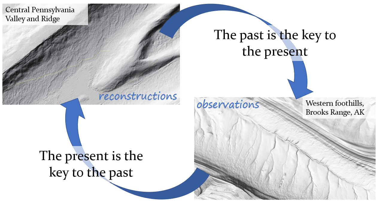
Long-lived records of climate and erosion from hillslope cores: central Appalachia
Plain English: The chemistry of deeply buried sediments tell me that the chemical and physical breakdown of rock changed when central Appalachia began to experience cold temperatures almost a million years ago.
In August 2018 we drilled an 18 m core through periglacial debris and into an ancient saprolite on a hillslope in a headwater catchment in central Pennsylvania. Using measurements and models of cosmogenic nuclide 10Be and 26Al concentrations, I find that (a) periglacial debris was first deposited around the Mid-Pleistocene Transition, demonstrating extremely slow erosion rates and long residence time of regolith and (b) erosion rates in the pre-periglacial saprolite are 2-5x slower than erosion rates derived from modern and ancient periglacial debris. See a recent poster showing this work, and the GSA Bulletin paper from my master’s thesis that reported similar results.
[metaslider id=376]
Paired paleoecology-paleoerosion records from the Pleistocene-Holocene transition: central Appalachia
See the GSA 2020 talk and bonus figures here.
Plain English: By studying sediments accumulating in a bog whose history spans a cold-to-warm climate transition, I can learn about how erosion and ecosystems responded to changes in climate. I can also figure out how long it took for the landscape to reach its current form once climate change began.
Although pollen-based reconstructions of central Appalachia’s past tell us how vegetation changed after the Last Glacial Maximum, we don’t know as much about how the landscape itself changed, including the timing and rate of erosion in response to warmer and wetter conditions in the Holocene. We used ground-penetrating radar and coring to study sediments at Bear Meadows Bog and counted pollen on radiocarbon-dated intervals to generate a high-resolution record of sedimentation and ecology over the cold-warm transition. By including geochemical data from my hillslope study, I could also pin down the timing and rate of dust deposition versus hillslope processes in my core, clarifying the source to sink mass balance and showing how dust is both an important geochemical and geomorphic agent in sandstone ridgelines. You can read my GSA 2020 abstract here.
[metaslider id=382]
Topographic and climate controls on active permafrost hillslopes: western Alaska
Plain English: What makes permafrost landscapes erode? We measure movement of soil with many tools and compare the patterns of movement in time and space to trends in temperature and rainfall as well as where the moving soil is located on the landscape. If we understand how and where permafrost soil erodes, we can know whether we need permafrost-specific models of erosion for permafrost landscapes (but perhaps models describing non-frozen soil work too!).
Through a graduate research funding program at the Department of Energy, I am working with scientists at Los Alamos National Lab on the NGEE-Arctic project to study this critical ecosystem (read a broad overview of our science goals in my 2019 AGU abstract). We use drone-acquired photos, multiannual GPS measurements and InSAR to quantify the rate and timing of erosion on permafrost hillslopes. We use these results to show the climate and topographic influences that control where and when failures occur. In particular we’re interested in determining whether geomorphic models developed for temperate landscapes can explain the patterns we see in permafrost erosion or if there is a distinct “signature” of ground ice and thaw in the patterns.
Tundra landscape dynamics at previous warm periods: western Alaska
Plain English: What happened the last time western Alaska was as warm as it is now? We reconstruct how sediment and carbon moved on a landscape that was undergoing changes in temperature, moisture and vegetation community. These past records of landscape change might tell us how vegetation and climate will affect eroding permafrost in the future.
As part of the NGEE-Arctic project I am establishing a paleoclimate-paleoerosion record from sediment cores from hillslopes around the Seward Peninsula. Previous pollen studies in the area allow us to connect erosion rates inferred from hundreds to thousands of years ago to climate conditions, including the previous warm period at the Pleistocene-Holocene transition. I am using radiocarbon, organic geochemistry and pollen and charcoal counts to examine how erosion rates changed as a function of climate change, an in particular I am interested in determining whether maximum erosion occurred under warm/wet or warm/dry (and thus-fire-prone) conditions. This distinction is important as the Arctic is expected to get both warmer and wetter in the future, and the trajectory of tundra vegetation and fire under these conditions is uncertain.
Channel geometries shaped by bedrock fracture density and orientation: western New York
Plain English: The dramatic gorges of the Finger Lakes are formed in layered sedimentary rocks with pervasive 90-degree fractures. Rivers display a spectrum of forms – from round, sculpted chutes to broad, blocky falls. Why are some waterfalls tall and skinny, short and wide, and everything in between? I’m trying to connect the fracturing of the bedrock to the variety of river shapes we see in western New York and elsewhere.
In a study that grew from a class project, I am investigating how both horizontal and vertical variability in rock strength control bedrock incision styles. Despite the fact that most gorges in the Finger Lakes are formed in the same 100 meters or so of sedimentary rock, channel width and steepness are quite varied. I am learning that, in addition to rock strength variability imparted by the layered deep marine rocks of the Ithaca Formation, vertical fracture density and orientation impart important cross-site variability in channel form. This is particularly relevant if we try to reconstruct base-level changes from knickpoint size and elevation. Tectonic and climate signals are generally assumed to produce oversteepend reaches that migrate through a landscape, but that story might be complicated by spatially-variable rock strength.
[metaslider id=390]
Past projects:
Soils and chemical weathering in steep bedrock landscapes: San Gabriel Mountains, California
Does landslide debris act as an important source of solute in steep bedrock landscapes? For my senior thesis at Pomona College, I worked with visiting professor Karl Lang and Keck Sciences professor Colin Robins to investigate deeply weathered sedimentary deposits in the eastern San Gabriel Mountains. We quantified chemical weathering, classified soils forming on the debris and used luminescence dating to determine the age and chemical alteration of the deposit, which we determined was a landslide about 40,000 years old. Comparing our field data to chemical weathering models, we determined that eroding landslide deposits can act as steady sources of solute, but that their contribution does not outpace chemical weathering of erosion and thin soils that characterize most of the steep landscape. We published this work in Earth Surface Processes and Landforms, and the British Society of Geomorphology awarded this paper the Wiley Award for 2019.
Aspect-modulated diffusion on cinder cones: San Francisco Volcanic Field, Arizona
This was my first official research project! As part of a joint Northern Arizona University/Arizona State University Research Experience for Undergraduates (REU), I compared the north- versus south-facing slopes of dated cinder cone volcanoes in northern Arizona to determine how sediment transport efficiency might be affected by aspect. I used statistical tests to determine whether aspect, as well as vegetation, produced significantly different slopes. I then compared this field data to numerical model simulations of cinder cone diffusion at various transport efficiencies. (In true newbie fashion, I saved precisely zero files associated with this project, so the only record I have is the poster I saved from GSA 2014 that may have been KonMari’d in one of my grad school moves. Save your files, kids!)