We offer a robust set of tools and spatial services! Contact us to set up an appointment
SERVICES
- Data Science, Data Vis, Data transformation
 ESRI / ArcGIS consulting
 Spatial processing and visualization with R
  Spatial processing and visualization with Python
  SQL database extraction and loading
- Mapping
- Historical map scanning, data extraction and transformation
- Geocoding street addresses
- Workshops
- Guest lecturing
- Workflow development, python coding, ETL pipelines
- X-hour teaching
- Web-mapping
Tools
Previous Projects / Gallery
Publication-quality maps
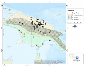
New Guinea bone daggers were engineered to preserve social prestige
Nathaniel J. Dominy, Samuel T. Mills, Christopher M. Yakacki, Paul B. Roscoe and R. Dana Carpenter
Published:25 April 2018 https://doi.org/10.1098/rsos.172067
https://royalsocietypublishing.org/doi/full/10.1098/rsos.172067
Machine Learning and Image classification with ArcGIS & Python Code
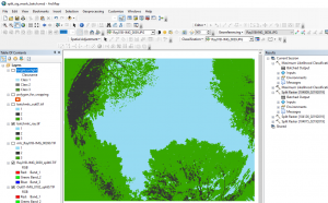
Data Extraction from scanned historical maps
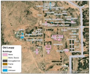
Shimásání dóó shicheii bi’ólta’ – My Grandmother’s and Grandfather’s School: The Old Leupp Boarding School, A Historic Archaeological Site on the Navajo Reservation. Two Bears, Davina Ruth. Indiana UniversityProQuest Dissertations Publishing, Degree Year2019. 22616943. https://www.proquest.com/docview/2305191109/abstract/6EE7BC5D6DC840DAPQ/1?accountid=10422
Web Mapping with Leaflet.js
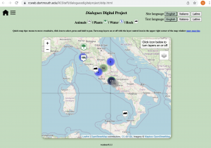
Publication: The Dialogues Bioregional Project: Landscape Ecology in Central Italy from the Sixth Century to the Present
Damiano Benvegnù
https://journals.oregondigital.org/index.php/hsda/article/view/4542
DOI: http://dx.doi.org/10.5399/uo/hsda.6.1.5
Surface Contour Extraction, Transformation and Visualization
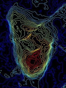
Footprint evidence of early hominin locomotor diversity at Laetoli, Tanzania Nature volume 600, pages468–471, published: 01 December 2021
Ellison J. McNutt, Kevin G. Hatala, Catherine Miller, James Adams, Jesse Casana, Andrew S. Deane, Nathaniel J. Dominy, Kallisti Fabian, Luke D. Fannin, Stephen Gaughan, Simone V. Gill, Josephat Gurtu, Ellie Gustafson, Austin C. Hill, Camille Johnson, Said Kallindo, Benjamin Kilham, Phoebe Kilham, Elizabeth Kim, Cynthia Liutkus-Pierce, Blaine Maley, Anjali Prabhat, John Reader, Shirley Rubin, Nathan E. Thompson, Rebeca Thornburg, Erin Marie Williams-Hatala, Brian Zimmer, Charles M. Musiba & Jeremy M. DeSilva
Nature volume 600, pages 468–471
Geocoding street addresses to base maps
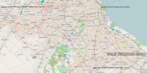
We support developing reproducible workflows for research using R and Python with spatial libraries and spatial data.
Links
- How do I....Research Computing ITC knowledge base
- Install ArcGIS Pro or ArcMap
- Log in to ArcGIS Online
- Mac GIS - QGIS
- ITC Services - GIS - https://services.dartmouth.edu/TDClient/1806/Portal/Requests/ServiceDet?ID=31692
- ITC Help Desk, Research Computing @ Dartmouth ITC
- Research Computing DartFS Storage and High Performance Computing Research Computing Home Page
- Research Computing Contact Us https://dartgo.org/rc-contact-us
- ITC help desk: ITC Home Page, Client Portal, and Help Ticket System and knowledge base ITC Knowledge Base
- We collaborate and work with
- Geography Department's Citrin Lab https://spatial.host.dartmouth.edu/
- Anthropology Department's SPARCL Lab https://sites.dartmouth.edu/sparcl/
- Dartmouth Library's Evans Map Room https://www.dartmouth.edu/library/maproom/gis.html
Posts
-
Introduction to Databases and SQL
Introduction to Databases and SQLCategory: Reproducible Research
-
Upcoming training
Upcoming training, navigate your browser to dartgo.org/rradworkshops or click the link below: https://libcal.dartmouth.edu/calendar/reproducibleresearch
-
GIS Resources – ArcGIS Desktop, ArcGIS Online, ArcGIS Pro
Link to recently-updated GIS knowledge-base article: https://services.dartmouth.edu/TDClient/1806/Portal/Requests/ServiceDet?ID=31692
- Introduction to Databases and SQL
- Upcoming training
- GIS Resources – ArcGIS Desktop, ArcGIS Online, ArcGIS Pro
- Dartmouth College ESRI ArcGIS concurrent license updated
- Workshop: Introduction to GIS

