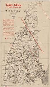
Our series highlighting a digital collection or item relevant to this day in history, by Monica Erives, Edward Connery Lathem ’51 Digital Library Fellow.
On this day in 1932, a total solar eclipse cast a shadow over a large portion of New Hampshire situated in its path of totality. This eclipse edition map, created by the New Hampshire State Highway Department, shows the center and limits of totality within NH, along with road and construction information for the exciting solar eclipse day. Sadly, Hanover was not within the lines of totality, but I’m sure it was still quite a sight to see! Not to mention it was a much shorter drive to view totality than last week’s solar event.
This map comes to us from The Granite State in Maps, 1756-2003 Collection, where there are over 600 unique NH maps – snapshots in time of the granite state.
View more solar eclipse items in the Dartmouth Digital Collections.


